
BBQ Facilities
The following BBQs and huts are available for bookings by filling in a BBQ Booking Form (312 kb) or contacting Customer Services on (03) 6261 8500.
Tynwald Park - Is a popular place for family BBQs and picnics, the park has several sheltered BBQ areas equipped with electric BBQs.
There is a fenced children's educational bike track complete with traffic lights and road signs. Some other facilities include fitness equipment, cricket nets, soccer and football oval, public toilets with disabled access and children's play equipment. Why not enjoy a walk along the banks of the Derwent River? (see walking and riding tracks).
The Esplanade - This park is located on the banks of the beautiful Derwent River. The Esplanade has a combination of open space and is the venue for outdoor events throughout the year. There are public toilets, a fenced, sensory playground and outdoor gym equipment for use.
Located within the fenced playground area, there are has two sheltered BBQ areas equipped with accessible electric BBQs.
There are four accessible BBQ tables located on the Esplanade, one in each of the covered shelters, and one at each end of the walking track, closest to the parking areas.
Why not come and feed the local ducks something duck friendly like lettuce, carrot, peas or corn - never bread. Or, if you're feeling energetic take a walk up the 99 steps along the Derwent Cliffs Walk to Tynwald Park?
Gleeson Park - Is located approximately 8 minutes (by car) from the centre of New Norfolk. The park has a large shelter complete with a electric BBQ, nearby public toilets, children's play equipment and open space for ball sports.
Granton Reserve - Granton Reserve is approximately 15 minutes (by car) from New Norfolk. It has a sheltered BBQ area complete with a electric BBQ. There is a lawn area along with children's play equipment and access to public toilets.
Walking Tracks
Looking to get lost amongst the giants and spot a Tassie Tiger or two? Try your luck on one of these trails...
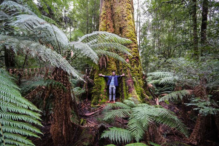
Photo credit: Tourism Australia & Graham Freeman
Riverside walk featuring historic buildings and bridge, established deciduous trees. Joins with the Derwent Cliffs Walk.
A gentle meandering track that follows the Lachlan River connecting with Tynwald Park and The Esplanade.
Stunning views of the Derwent River and cliffs.
Styx River Walk is a 1.1 kilometre lightly trafficked out and back trail that features a river and is good for all skill levels. The trail is primarily used for hiking and walking.
Positioned near Tyenna, just 10 mins drive past Mount Field National Park, Marriott’s Falls is a hidden gem to rival the beauty and spectacle of the nearby Russell Falls.
One of the most accessible, and beloved, waterfalls in Tasmania is Russell Falls, situated within the Mount Field National Park, 30 minutes past New Norfolk.
The Lady Barron Falls Circuit is a great short walk encompassing all the main points of interest within the lower section of Mount Field National Park.
Located within upper reaches of the Mount Field National Park, the Mount Field East circuit combines alpine scenery, idyllic lakes and lush rainforest in a spectacular trail.
Timbs Track is a 9.2 kilometer moderately trafficked out and back trail located in the state of Tasmania, Australia that features a river and is rated as moderate. The trail is primarily used for hiking and nature trips and is accessible year-round.
Located in the South-West National Park, Mount Eliza is the shorter and more accessible walk to that of the demanding hike to Mt Anne, looming off to the north-east.
Fishing Spots
Want to see why local lore claims you can't see the river for the trout? Cast your line at one of these spots...
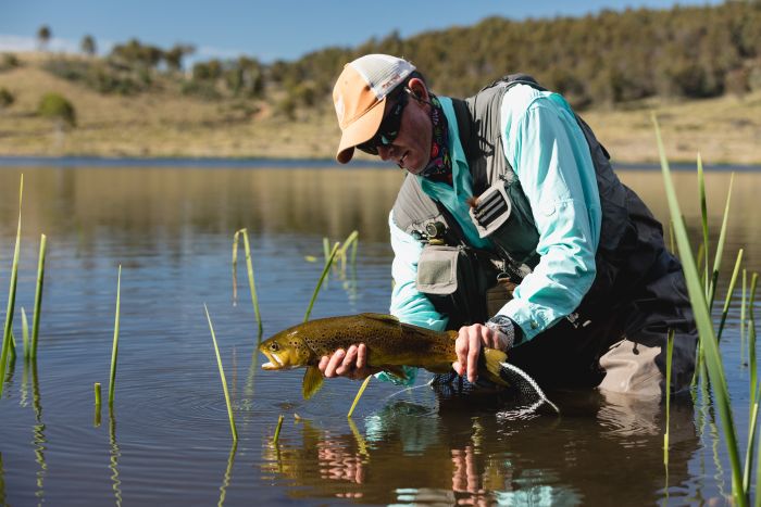 Photo credit: Samuel Shelley
Gently sloping track through bushland to popular fishing location.
Various locations along the Esplanade including opposite the caravan park, the breakwall at pontoon and purpose built platform accessible via foreshore pathway. Jetty on Rocks Road.
Access Anglers Access brochure for the River Derwent. This brochure covers a 75 km section of the river from Gretna to just downstream of the Bowen Bridge in Hobart’s northern suburbs.
The Tyenna River is approximately 20km north west of New Norfolk via the B62 and/or B61. Most access points lie between the townships of Westerway and Maydena.
Scenic views and lookouts
Are you looking to take an insta-worthy pic to make all of your friends jealous? Head to one of the spots and get snapping...
#UnquestionablyDerwentValley
Pulpit Rock Lookout
Pulpit Rock Lookout towers on a cliff just north of the picturesque town of New Norfolk. With the town framed just south of the river, you'll get views of lush rolling hills, open farmland and a bend in the Derwent River.
The lookout is just a short walk from its carpark, but finding the lookout can be tricky as it sits at the end of a windy dirt track. The Pulpit Rocket Lookout is a quick excursion worthy of a few social media pics and perhaps a family picnic. You just have to know how to get there. More info
Peppermint Hill Lookout
Just a short drive from New Norfolk town centre, Peppermint Hill lookout rewards visitors with fantastic views of New Norfolk and the River Derwent looking back towards Hobart. More info
Gordon River Dam
The Gordon River Dam is a view that will definitely take your breath away, even if you’re not scared of heights! The dam wall is 140 metres high and is a spectacular sight, particularly if there are daredevils abseiling down the face of the wall. The Gordon Dam holds water from the large lakes of Lake Gordon and Lake Pedder and creates 13% of the power used within Tasmania.
The Gordon River Dam is found 2.5 hours to the west of Hobart. Visitors will need to travel northwest through the small town of New Norfolk before turning onto the B61 at Bushy Park to get to this amazing and picturesque spot. More info
Still got time to kill? Check out the Walking Through Time podcast
Walking Through Time is a walking trail with interpretative signage linked by podcasts giving a unique view of the history of New Norfolk. There are 9 storyboards that cover the history of New Norfolk placed at strategic points around the town, each has a QR Code and a URL to access the sound files via phone or web browser.
The storyboards are located at Tynwald Park (there are two boards here, including an indigenous history of the area), Turriff Lodge walking track, one at each end of the Esplanade, opposite the Bush Inn, Arthur Square, Circle Street (outside Council Chambers) and opposite the entrance to the Barracks in The Avenue. Each board tells its own story and can be viewed individually or you can take the entire walk and learn many quirky facts along the way.
Map of Walking Through Time storyboard locations.
This project was jointly funded by the Australian Government through the Your Community Heritage Program and Derwent Valley Council for the enjoyment of the people of the Derwent Valley and as a point of interest to visitors.
-
Ellis Dean Reserve
Blair StreetSA